
Salmon River Phase 3 Project in Oswego County, NY
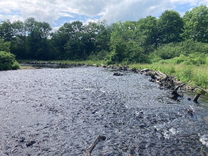
The Lake Ontario Committee (LOC) agencies are undertaking stocking and habitat restoration projects to re-establish native Atlantic salmon in Lake Ontario, particularly in key locations like the Salmon River. The project site on the Salmon River is an area where degraded riparian and stream conditions are contributing to unsuitable habitats for Atlantic salmon. Historic hydroelectric generation operations have created an unstable channel in the Lower Salmon River, which has interrupted natural sediment transport, degraded instream habitat, and induced excessive streambank erosion.
The proposed Salmon River Phase 3 project will remedy this situation as part of the Salmon River restoration effort. This project compliments restoration that has occurred upstream at five sites to address similar channel instability issues. The Phase 3 restoration sites are three reaches directly downstream of the Trestle Pool site (Salmon River Trestle Pool). Restoration of natural erosion and sedimentation processes, reconnection to the floodplain, and bank stabilization from this project will improve Salmon River habitats for Atlantic salmon and other native species. The project will directly address restoration of rearing habitat for juvenile Atlantic salmon (channel margin/toe wood installation) and enhance spawning habitat at upstream riffles. This project will achieve multiple community benefits by enhancing instream habitats for many native species through the restoration of natural sediment transport through riffle/pool/run sequences in the river and natural levels of bank erosion, as prescribed in the Salmon River Recreation and Restoration Plan. Additionally, the project will provide for enhanced recreational fishing in these reaches of the Salmon River. Lastly, the project will contribute to the LOC’s goal of restoring Atlantic salmon in the Lake Ontario basin.
The project will install over 1,200 linear feet (365 m) of toe wood bank stabilization structures in two reaches immediately downstream of the Trestle Pool Project. Additionally, J-hook vane structures will be installed at several potential locations. The toe wood and J-hook vane structures proposed are proven restoration techniques for moderate-to-high gradient stream reaches that are slightly-to-moderately meandering and are incising with excessive streambank erosion. All riparian areas will be planted with live stakes, seeded, and mulched once construction is completed.
Feasibility has been completed as a part of the Salmon River Recreation and Restoration Plan and preliminary engineering and design have been completed by USFWS staff. Final engineering and design plans will be completed by a contracted NY state licensed engineer. A contractor will survey the site prior to implementation to 1) establish bankfull elevations, and 2) collect other information to inform the final design as detailed in the Quality Assurance Project Plan. This survey work will include channel dimension and profile as well as substrate particle size. These data will be used to confirm that design velocity and discharge are reasonable. Finish elevations and final designs will then be provided to the contractor for construction.
As-built surveys and assessments of changes to instream and bank features (substrates, flows, etc.) and fish community responses (upstream/downstream) will be conducted on completion of construction. NYSDEC will continue to stock 80,000 Atlantic salmon yearlings annually as a part of its restoration efforts and conduct annual angler diary and creel surveys on the Salmon River.
Construction is currently planned for the summer of 2025. All New York State and USACE permits for the proposed work are in place and the Federal NEPA compliance has been initiated. To avoid potential impacts to young-of-year salmonids and reduce potential angler conflicts, work would be completed between June 15 and August 31, 2025.
Project partners include NYSDEC, USFWS, FLLOWPA, and NOAA. The NYSDEC Region 7 Fisheries Unit will act as the primary land manager through an interdivisional agreement with the Division of Lands and Forests and be the responsible party for operation and maintenance if needed. The project team does not expect that this project will need a hydrologic and hydraulic study, or any additional studies prior to implementation.
The physical and biological data pre- and post-construction, will be stored internally by USFWS NYFO and NYSDEC as well as on this website. The data will be available to the public on this website or upon request within 60 days of data validation and entry, starting during the summer, 2025, through the summer 2026. Contact Jeff Tyson for more information or to make a data request. All future sub-awardees not identified in this plan will have as a condition of their contract acceptance of this data sharing plan. Any additional data sharing stipulations for future sub-awardees may be outlined at that time and described in their contract.